Honda Fit: Map Input
 DEST button
►DEST Menu 2►Map Input
Use the joystick to manually select an icon or a location on the map screen as the destination.
You are prompted to define the map area to display.
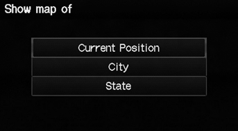
1. Select an item.
The following items are available:
• Current Position: Your current location is centered on the map.
• City: You are prompted to select the city.
• State: You are prompted to select the state.
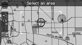
2. Scroll the map to position the cursor over your desired destination, adjusting the map scale as necessary. Press the ENTER button.
► If the address is not the desired location, scroll the map to another location and try again.
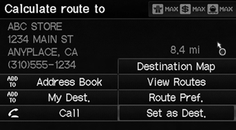
3. Press the ENTER button again to display the route calculation menu.
4. Select Set as Dest.
A yellow box (shown at scales above 1/4 mile) denotes the area that can be viewed when you press the ENTER button on the current map.
Information icons are displayed at scales from 1 mile to 1/4 mile. Place/landmark icons are displayed at 1/8 mile or less. Roads are displayed at 1/4 mile or less.
If you select multiple icons within the cursor radius, you are prompted to select one of the items from a list.
See also:
Rear Seat-Back Cover/Pad Replacement
Special Tools Required
KTC Trim Tool Set SOJATP2014
*Available through the Honda Tool and Equipment Program; call
888-424-6857
NOTE:
Use the appropriate tool from the KTC trim to ...
Dashboard Center Lower Trim Removal/Installation
Special Tools Required
KTC Trim Tool Set SOJATP2014
*Available through the Honda Tool and Equipment Program; call
888-424-6857
NOTE:
Take care not to scratch the dashboard or its ...
M/T Differential Carrier/Final Driven Gear Replacement (M/T)
Loosen the bolts in a crisscross pattern in several steps, then remove
the final driven gear (A) from the differential carrier (B).
Install the final driven gear with the cham ...
Categories
