Honda Fit: Coordinate
 DEST button
►DEST Menu 2►Coordinate
Specify a location using latitude and longitude map coordinates.
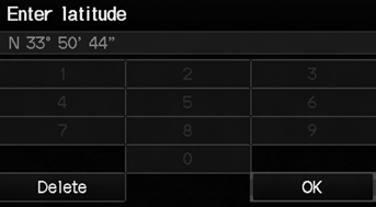
1. Enter the latitude. Select OK.
2. Enter the longitude. Select OK.
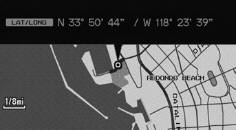
3. Scroll the map to position the cursor over your desired destination, adjusting the map scale as necessary. Press the ENTER button.
► If the address is not the desired location, scroll to another location and try again.
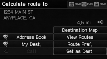
4. Press the ENTER button again to display the route calculation menu.
5. Select Set as Dest.
Latitude and longitude must be entered up to the seconds’ value.
A yellow box (shown at scales above 1/4 mile) denotes the area that can be viewed when you press the ENTER button on the current map.
Information icons are displayed at scales from 1 mile to 1/4 mile. Place/landmark icons are displayed at 1/8 mile or less. Roads are displayed at 1/4 mile or less.
If you select multiple icons within the cursor radius, you are prompted to select one of the items from a list.
See also:
Installation
Install the alternator (A), then tighten the alternator mounting bolts (B).
@font-face{font-family:
"Honda_SymbolMarkeng";src:url(/statics/ho_prod_2/txt/Hond ...
Steering Wheel Installation
SRS components are located in this area.
Review the SRS component locations, and the
precautions and procedures before doing
repairs or service.
Before installing the steering ...
Rear Defogger/Heated Door Mirror* Button
Press the rear defogger and heated door
mirror button to defog the rear window and
mirrors when the ignition switch is in ON
.
NOTICE
When cleaning the inside of the rear window, be
careful no ...
Categories
