Honda Fit: Coordinate
 DEST button
►DEST Menu 2►Coordinate
Specify a location using latitude and longitude map coordinates.
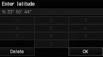
1. Enter the latitude. Select OK.
2. Enter the longitude. Select OK.
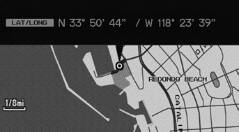
3. Scroll the map to position the cursor over your desired destination, adjusting the map scale as necessary. Press the ENTER button.
► If the address is not the desired location, scroll to another location and try again.
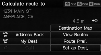
4. Press the ENTER button again to display the route calculation menu.
5. Select Set as Dest.
Latitude and longitude must be entered up to the seconds’ value.
A yellow box (shown at scales above 1/4 mile) denotes the area that can be viewed when you press the ENTER button on the current map.
Information icons are displayed at scales from 1 mile to 1/4 mile. Place/landmark icons are displayed at 1/8 mile or less. Roads are displayed at 1/4 mile or less.
If you select multiple icons within the cursor radius, you are prompted to select one of the items from a list.
See also:
Find Nearest Place
MAP MENU (on map)
►Find Nearest…
Search for the nearest place/landmark on the map screen and set it as your
destination.
1. Select Find Nearest….
2. Select a category type.
3. Selec ...
Hood Adjustment
NOTE:
Put on gloves to protect your hands.
Take care not to scratch the hood, the body, or other related parts.
Remove the cowl cover.
Slightly loosen each bo ...
Audio Screen Control
AUDIO button (in BT mode)
Control the audio screen through the navigation system.
Select an item.
The following items are available:
• GROUP: Select or
to select a playlist, album, genre ...
Categories
