Honda Fit: Map Input
 DEST button
►DEST Menu 2►Map Input
Use the joystick to manually select an icon or a location on the map screen as the destination.
You are prompted to define the map area to display.
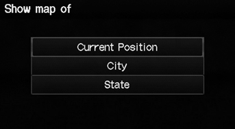
1. Select an item.
The following items are available:
• Current Position: Your current location is centered on the map.
• City: You are prompted to select the city.
• State: You are prompted to select the state.
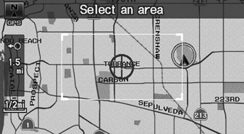
2. Scroll the map to position the cursor over your desired destination, adjusting the map scale as necessary. Press the ENTER button.
► If the address is not the desired location, scroll the map to another location and try again.
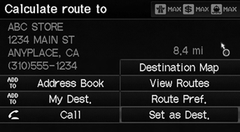
3. Press the ENTER button again to display the route calculation menu.
4. Select Set as Dest.
A yellow box (shown at scales above 1/4 mile) denotes the area that can be viewed when you press the ENTER button on the current map.
Information icons are displayed at scales from 1 mile to 1/4 mile. Place/landmark icons are displayed at 1/8 mile or less. Roads are displayed at 1/4 mile or less.
If you select multiple icons within the cursor radius, you are prompted to select one of the items from a list.
See also:
Refilling Window Washer Fluid
Models without washer level sensor
Check the amount of window washer fluid. Look for 1/2 mark on the reservoir.
If the level is low, fill the washer reservoir.
Models with washer level senso
If ...
Online Reference Owner's Manual
This owner’s manual should be considered a permanent part of the
vehicle and should remain with the vehicle when it is sold.
This owner’s manual covers all models of your vehicle. You may find ...
Regulator Valve Body Disassembly, Inspection, and Reassembly (A/T)
Clean all parts thoroughly in solvent, and dry them with compressed air.
Blow out all passages except the air check valve filter.
Inspect the regulator valve body for scoring and ...
Categories
